 |
|
Lake Erie PDF File |

|
Lake ErieFacts | Formation | Glaciers | Hotlist Facts
Sources:
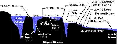
FormationThe foundation of the total area known as the Great Lakes was laid about 3 billion years ago during the Precambrian Era. During that era, great stresses caused volcanic activity and great mountain formation. Sedimentary rocks and volcanic rock were heated and folded into complex structures and then folded and eroded. In the northeastern part of North America, gentle hills and small mountains developed and became known as the Canadian Shield (also called the Precambrian Shield or the Laurentian Plateau). The Canadian Shield is a 1.9 million-square-mile, horseshoe-shaped region that covers central and eastern Canada and a little of the Northeast United States. The Shield, which accounts for about half of the area of Canada, is made up of hard, crystalline rocks -- among the oldest in the world.
Glaciers
The most recent Ice Age began about 2.5 million years ago. During this time, a continental ice sheet covered the region that developed into glaciers. There were at least four glaciations during this time: the Nebraskan (1million years ago); the Kansan (700,000 years ago); the Illinoian (about 225,000 years ago); and the Wisconsin (about 22,000 years ago). A "likely scenario" for the formation of the glaciers (called the "lake effect" theory) is that the Arctic ice cap melted, but the Arctic remained cold. This caused a "lake effect" snow that blanketed the area with snow for many years. The snow became a "mile-high sheet of ice" and stayed in place for 100,000 years. (The snow stopped only when the Arctic Ocean froze again.) This accumulation of snow had tremendous weight and caused the lower layers of ice to be in a "plastic state" and to move away from the center of the accumulation. Lobes of ice moved forward and then retreated back from different centers and in different directions. The lobes carried different material, depositing rock debris in a variety of locations. Often the tip of the ice lobe melted, but the ice was pushed ahead. This meant that in some locations there was considerable debris deposited resulting in a range of great hills (terminal moraines). Because the land was greatly depressed, large glacial lakes formed (much larger than the current Great Lakes). As the glacier retreated, the land began to rise The major flow patterns and general configuration of the Great Lakes were fixed about 5,000 years ago.
This theory does not give a satisfactory explanation of what caused the end of the Ice Age. It is believed that the "ocean currents theory" better explains the end. These theories are based upon what "geologists call the 'Principle of Uniformitarianism,' where the present effects of several geologic agents are used to interpret the happenings of the past" (Door and Eschman, 1970).
Hotlist:
|